NOVOTEL AMSTERDAM CITY, The Netherlands
THEME: Enabling tomorrow’s Connected Infrastructure


MEET THE INDUSTRY LEADERS


INTRODUCTION
GEO| Design+BIM is an exclusive platform in Europe that highlights and initiates discussions related to the use of geospatial data analytics and 3D modeling in spatial design, construction, operation and maintenance. The event, combination of two innovative platforms: GeoDesign Summit Europe and GeoBIM Europe, was rebranded in 2017.
Understanding the relevance and importance of bringing the geospatial analytics, spatial planning, architecture, engineering, and construction and operation/maintenance professionals together on one platform, the integrated event will once again convene in Amsterdam from 1-2 November 2018.
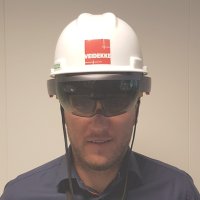
This year, GEO| Design+BIM will delve further into the integration of geospatial technology and BIM; and other associated industry trends including big data analytics, IoT sensors, drones, virtual reality (VR) and augmented reality (AR), robotics, cloud worksharing, modular/offsite construction, city information modeling, etc.
Theme
Enabling tomorrow’s connected infrastructureThe arrival of sensor, analytics, and cloud technologies is transforming the construction industry. There is no guessing what the building we live, play and work in will be like 10-15 years from now. Will the infrastructure that we use in our day-to-day lives operate in the same way? With the emergence of Internet of Things (IoT), there are new and critical considerations to think about while designing and constructing a new building/infrastructure.
Gartner, in its report ‘Forecast: The Internet of Things, Worldwide’, predicted that by the year 2020, connectivity will become a standard feature. The possibility of connecting virtually everything, from the simplest to the most complex object, offers remote control, monitoring and sensing capabilities to buildings and infrastructure operators. It is up to the planners, architects, engineers, and builders to ensure the building and infrastructure that we build today are IoT-ready in the future.

So how does BIM play a role in this?
The spatial data and asset data that comes with BIM provide a framework for the organization and analysis of IoT data in a way that is meaningful to building and infrastructure operations. Without BIM, information coming from sensors and devices are just silos, unusable information. Integrating BIM in the planning, design, and construction processes today will not only increase efficiency and productivity of a project; it is also a measure of preparedness to the hyper-connected world that we envision for tomorrow.
KEY PROGRAMS


WHO SHOULD ATTEND?

Architecture Firms

Building Operators

Building Owners

Construction Companies

Consultants (Environmental/ Engineering/ Project Management)

Engineering Companies

Facilities Managers

Hardware and Software Vendors

National Geospatial Agencies

Policy Makers

Professional Bodies

Project Owners

Research Institutions & Academia

SMEs/System Integrators
REGISTRATION FEES
| Delegate Categories | Fee (€)* |
| Professionals | 350 |
| Students | 100 |
Registration fee is inclusive of:
- Access to conference and display area for two days
- Tea/coffee breaks, lunches and evening reception
- Conference materials
Partners


GEO|Design+BIM 2017

- 2ba
- 3d + geosolutions bv
- ABLAT CONSTRUCTION
- Acto informatisering b.v.
- Adtollo AB
- AEC3
- AECOM
- AeroVision
- Agency9 AB
- Almere
- Amsterdam Airport Schiphol
- Amsterdam ArenA
- APOGEA
- Arcadis
- Arini Geographics
- Arkey Systems
- Arkey Systems bv
- Armatiek
- Arup
- Atkins
- Atos
- Authority for Consumers and Markets (ACM)
- Autodesk
- Avineon
- Bakker & Spees
- Balance & Result
- Ballast Nedam
- Bam Infraconsult
- Bentley Systems
- Between The Poles
- BHO Legal
- BIM Academy
- BIM Intelligence
- BIM Loket
- Bimetica
- Bimit
- BIMscript
- BIMW
- BNA
- Bo-Ex
- Boskalis Nederland
- Bouwconnect-Twee Snoeken
- Bouwend NL
- Braindex
- BRGM
- BRIS
- Brno University of Technology
- BS+R Bernard Schenk SA
- BSI Group
- Building Bits
- buildingSMART International
- Burgerhout
- Business Collaborator Limited (GroupBC)
- Business Geografic
- CAD & Company
- Cad accent
- CAD Magazine
- CBNL
- CITA
- City of Ghent
- City of Rotterdam
- Clearbox
- Communicatie
- Compris Consulting
- Con terra
- Connecting projects bv
- Construsoft
- Corstens informatie-architectuur
- Croon Elektrotechniek b.v.
- CROW
- Csn groep
- CSTB
- CycloMedia Technology
- CYIENT
- Data design system
- Delft University of Technology
- DelftTech BV
- Deloitte
- Deltares
- Department of Survey and Mapping
- Don bureau
- Drift engineering
- Dura Vermeer
- Dutch Building Information Council
- Dutch Ministry of Infrastructure & the Environment
- EBC - European Builders Confederation
- EGIS
- Eindhoven University of Technology
- Ellbru
- ESC
- Esri
- Ethan Trading Company Ltd
- Etim Nederland
- European Commission, Joint Research Centre
- Everspartners
- FARO Europe GmbH& Co. KG
- FIEC - The European Construction Industry Federation
- French Geological Survey (BRGM)
- FT Laboratories Ltd
- Fugro GeoServices B.V.
- Gaia3D,.Inc
- Gebr. van der Lee
- Gellish.net
- Gemeente Rotterdam
- GEO SOLUTIONS NV
- GeoBusiness Nederland
- GeoCensus
- Geodan
- Geodesign Hub Pvt. Ltd.
- Geodezia Ltd.
- GEOInformatics
- Geological Survey of Norway
- Geomaat B.V.
- Geometius
- Geonardo Environmental Technologies Ltd.
- GeoNext
- Geonius techniek & innovatie
- Geonovum
- Geospatial OÜ
- Gexcel Srl
- GIS-Magazine
- Gobar Consulting Group
- Grontmij Nederland B.V.
- GSP Network GmbH
- HCP international
- Head Office of Geodesy and Cartography
- Heijmans
- Hertek
- Het Nationaal BIM Platform
- HFB
- High Speed Two (HS2) Limited
- Historic England
- Hochtief Infrastructure
- Hogeschool Utrecht
- Hogeschool Windesheim
- HZI
- ICRC
- IDM Solutions B.V.
- IDP Ingeniería y Arquitectura Iberia S.L.U.
- IES Ltd
- IESVE
- IGN
- Ihw
- Informagic
- Infostrait
- Infrakit B.V.
- iNFRANEA
- Ingenieursbureau Amsterdam
- Inqa Quality Consultants B.V.
- Institut Cartografic i Geologic de Catalunya
- Institut Municipal d'informàtica - Ajuntament de Barcelona
- IntraTeamIT Consultants
- Ipcon
- IQSOFT Gesellschaft fuer Informationstechnologie mbH
- Istanbul Technical University
- Itannex
- iTech Management Consultancy
- Iv-Infra b.v.
- JP van eesteren
- JTC Corporation
- Kadaster
- Kastell Konsult
- Keynetix Ltd.
- Klokgroep
- Knauf b.v.
- Komatsu Europe International
- KondorWessels Oost
- KTH Royal Institute of Technology
- L3S Research Center
- Landinspektørfirmaet LE34
- Lansec
- Lechner Nonprofit Ltd.
- Leica Geosystems
- Local Zoom
- LUCIAD
- Mapita Ltd
- Mercury Middle East WLL
- Metropolitan Water District of Southern California
- Ministry of Environment and Water Affairs
- Ministry of Infrastructure and Environment
- Ministry of Justice
- Mister BIM
- MK University
- Movares
- Movares Nederland B.V.
- Municipality of Rotterdam
- Municipality of The Hague
- Mwh b.v.
- National Land Survey of Finland
- Neanex
- NedGraphics B.V.
- Nemetschek scia
- Newcastle University
- NIRAS
- NORCONSULT AS
- NØRD Amsterdam / buro NORD
- Novia University of Applied Sciences
- OGC
- Oldfield language
- Omkeere
- Only bim bv
- Open Geospatial Consortium
- Oracle
- Ordnance Survey
- Patina groep b.v.
- Pix4D
- Planon
- Plaxis bv
- Plinacro Ltd
- PROCOS
- Professional Construction Strategies Group ( PCSG)
- ProRail
- Province of Gelderland
- Provincie noord-brabant
- Provincie Noord-Holland
- Public Business Division, AllforLand
- Ramböll Sweden
- Relatics
- Remote Sensing Solutions
- Research Institute of Geodesy, Topography and Cartography, v.v.i
- Revit Standards Foundation
- RIEGL Laser Measurement Systems
- Rijksdienst voor ondernemend Nederland
- Rijksvastgoedbedrijf
- Rijkswaterstaat
- Road Management Co. of Municipality of Budapest)
- Roeleveld-sikkes architects
- Royal HaskoningDHV
- Ruimteschepper/ GeoSpotter
- RWTH Aachen University
- Safe Software
- SAGEO
- Sas institute
- SBRCURnet
- Schouten techniek
- SCIA
- Semmtech B.V.
- Siemens AG
- Smart Dots - METU
- Smits bouwbedrijf b.v.
- Solidu
- Soul Definition
- Spatial Sciences Institute
- Spekkink
- Spoorzone Delft
- SRV Construction Ltd
- Stabiplan
- STABU Foundation
- Staka bouwproducten b.v.
- Stichting Arbeidsmarkt Geo
- Strukton Civiel Projecten
- Sweco
- Swiss Federal Office for Spatial Development
- swisstopo
- Syndicat de l'Architecture
- Sysunite
- Tauw bv
- TAV Construction
- Technisch handelsbureau Rensa
- Technische Universität München
- Teesside University
- The Hague University of Applied Sciences
- The Location Lab GmbH
- The Royal Danish Academy of Fine Arts
- Thomas More Hogeschool
- TIF
- Tinbergen Institute Amsterdam
- TNO
- Topcon
- Tracasa
- Transreality.com BV
- Trigonet AG
- Trimble
- TUC RAIL
- TUE Eindhoven University Of Technology
- UCL
- Unica
- Unilever
- Universidad Politecnica de Madrid
- Università degli studi della Campania
- Universiteit Twente
- University of Amsterdam
- University of Applied Sciences and Arts Northwestern Switzerland
- University of Applied Sciences Stuttgart
- University of Applied Sciences Western Switzerland - hepia
- University of Liverpool
- University of Salzburg
- University of South Australia
- University of Southern California
- University of Twente
- UPC, Polythecnic University of Catalonia
- UWA
- Van Meijel Automatisering
- Van Oord
- Vericon ingenieurs bv
- Vianova Systems
- Vicrea
- VolkerWessels
- VSB-Technical university of Ostrava
- VU Amsterdam
- Wagemaker
- Wageningen University and Research Centre
- Waternet
- Wavin
- Weihenstephan-Triesdorf University of Applied Science
- Witteveen+bos
- Wolter & Dros b.v.
- WSP
- Znz-beheer